

MORE ABOUT OUR SCUBA EXCURSIONS:



Type:
Italian Transatlantic Liner
Name:
SS Andrea Doria
Built:
1959, Netherlands
Specs:
697 ft long; 90 ft beam and a gross register tonnage of 29,100) 1000 gross tons, 12 crew.
Sunk:
July 25th, 1956
Collided with the MS Stockholm, 300 miles east of New York, killing 51 people.
Depth:
Approximately 240 feet
July 25th, 1956, the SS Andrea Doria, part of Italy’s transatlantic liner fleet, collided with the MS Stockholm, 300 mile east of New York, killing 51 people. This tragedy became one of the largest civilian maritime rescues in history.
An ocean liner known for its beauty and safety features, she completed 100 transatlantic crossings between 1953 and 1956; but the 101st crossing would be different. After leaving Italy on July 17th, 1956, the Doria stopped in the Mediterranean at three ports, and then continued into the open ocean on a nine day voyage to New York City.
The Doria carried 572 crew members and 1,134 passengers who came from various backgrounds; from Italian immigrant families, vacationers, to business travelers and a few famous people such as Hollywood actress Ruth Roman.
Approximately 10:30 pm, both ships approached each other from opposite directions off Nantucket. Captain Piero Calamai of the SS Andrea Doria directed the ship to slightly reduce the Doria’s speed to say on schedule to arrive in New York early the next morning, despite the heavy fog. Research shows that the Stockholm vessel was pushing north of the recommended eastbound route in an attempt to save time on its schedule.
Before 11:10pm, Captain Calamai spotted Stockholm’s lights through the dense fog. An officer on the Doria yelled “She’s coming right at us”; Calamair ordered a sharp left turn to try to outrun the Stockholm. Meanwhile Carstens saw the Doria and tried to reverse his propellers to slow down but it was too late. The Stockholm’s icebreaker bow struck the Andrea Doria’s starboard side penetrating approximately 30 feet into its hull and snapping bulkheads. It ten broke loose and let a gaping hole in the side of the Doria.
Fortunately the ship was located in a heavily traveled strip of the Atlantic. Several vessels answered the Doria’s distress calls and came to assist the Stockholm who was rescuing passengers. Around 2 am the Ile de France, a large French ocean liner, approached the side of the Doria and used it’s floodlights to light up the Doria and help rescuing people with its lifeboats.
The largest rescue in maritime history lasted several hours. By 5:30am all of the Doria’s survivors were evalcuated. Five people on the Stockholm and 46 on the Doria totaled 51 people who died as a result of the collision.
There were clear mistakes made from both ships, however many believe that Carstens (Captain of the Stockholm) made the crucial error by misreading his radar and determined that the Doria was several miles farther away than it was. The debate over the cause of the wreck continues even today.

Type:
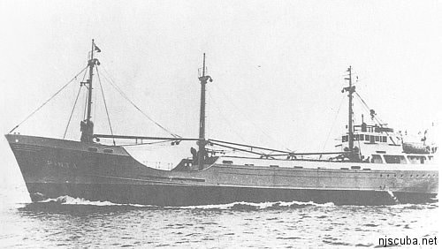
Shipwreck, freighter, Netherlands
Name:
The Pinta was one of three sister ships named for Columbus’ original three vessels, the Nina, the Pinta, and the Santa Maria.
Built:
1959, Netherlands
Specs:
(194 x 31 ft) 1000 gross tons, 12 crew
Sunk:
Wednesday May 8, 1963
Collision with freighter City of Perth ( 7547 tons ) – no casualties.
Depth:
85 ft. starts at 55 ft.
How two ships in the age of radar and on a clear day could collide on the open sea is a mystery. Nonetheless, we now have the Pinta as one of the best dive sites in New Jersey. This relatively small vessel lies on its port side on a clean sandy bottom. It is still quite recognizable as a ship, and is the perfect size for sightseeing – you can swim from end to end several times on a single tank of air. It also makes a good multi-level training dive.

Type:
shipwreck, liner, USA, Clyde-Mallory Lines ( sailing under Ward Lines )
Name:
Built:
Specs:
(387 x 54 ft) 5897 gross tons, 163 passengers & crew.
Sunk:
Thursday January 25, 1935
Collision with Norwegian freighter Talisman – 45 casualties.
Depth:
80 ft. max.
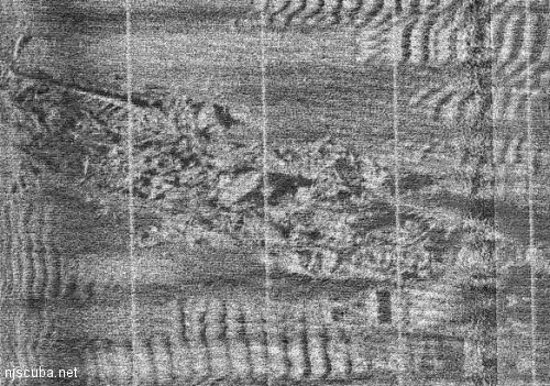
The Mohawk was given its name after a previous ship of the same name belonging to the same company burned and sank in Delaware Bay in 1952. Another Mohawk is sunk outside the mouth of New York harbor. Thus there are plenty of Mohawk wrecks in our area. This does not seem to be a lucky name.
Neither was the parent shipping company, Atlantic, Gulf & West Indies Steamship Lines, very lucky; the previous year, in an incident that is far more well-known than the sinking of the Mohawk, the Morro Castle caught fire and grounded in the surf off Asbury Park, a total loss. ( the hulk was eventually towed to a Baltimore wrecker’s yard. ) then, just weeks before the Mohawk was lost, the company’s Havana grounded on a reef, and the Mohawk was transferred to fill in for the damaged vessel on the New York – Havana – Vera Cruz (Mexico) run. Coincidentally, the Clyde Line also owned the Delaware, sunk nearby some 37 years earlier.

Type:
Name:
Stolt is the name of the line that owned the ship; it translates as “mountain” or “pride”. Dagali is a city in Norway.
Built:
1955, Denmark, as Dagali
Specs:
(582 x 70 ft) 12723 gross tons, 43 crew
Sunk:
Thursday November 26, 1964
(Thanksgiving day)
Collision with liner Shalom (25,338 tons) – 19 casualties.
Depth:
130 ft. Starts at 60 ft.
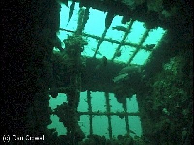
By all accounts the brand-new liner Shalom was proceeding at a recklessly fast pace through a thick fog, while simultaneously misreading her radar set. The slow-moving M-class tanker Stolt Dagali was sliced clean through, losing almost half her crew when the heavy stern section plummeted to the bottom of the sea. Fortunately, the Stolt carried a cargo of non-flammable vegetable oil, otherwise both vessels might have been consumed in flames. The bow section of theStolt was salvaged, while the stern section lies crookedly on its starboard side, 142 ft long in 130 ft of water. Survivors of the Stolt were picked up by the Cape Straight.


Type:
shipwreck, trawler, scallop dredge, USA
Built:
1973, Pascagoula MS USA
Specs:
(71 x 21 ft) 104 gross tons, 4 crew
Sunk:
Depth:
90 ft.
This little wreck is almost completely intact and upright, although now badly rusted and beginning to cave in. The hatch covers over the cargo holds are missing, and problems with these are probably the reason the vessel sank in the first place. The masts are broken off and lying in the sand, and the entire wreck is covered with sea life. Mussels are a foot thick on the top of the pilot house, along with thick stands of anemones. Lobsters can be caught in the sandy recesses around the hull, and be sure to shine your light into the big washout under the stern, where there is always a big bug lurking well out of reach. This is also sometimes a good wreck for scallops, and even the occasional Blackfish, although this small wreck can quickly be fished out of everything.
In the cargo hold, you can see the Lana Carol’s final haul of scallops. Higher up, the small cabin is opened up and safely and easily penetrated, although the doorway is a little tight. Under good conditions, this is probably the most picturesque wreck of the New Jersey coast. Over the winter of 2002-2003, storms moved the wreck about 10 feet “forward”, leaving her rudder embedded in the sand behind her.
The picture above is a sister ship of the Lana Carol. This vessel appears to be rigged for trawling, rather than scalloping, however. It is possible that this was her original configuration, which was probably for shrimp trawling in the Gulf of Mexico. In any case, it is very similar.

Type:
shipwreck, tanker (sometimes incorrectly identified as a barge)
Built:
1938, Staten Island NY USA
Specs:
(250 x 40 ft)
Sunk:
Thursday September 10, 1987
Sponsor:
Crystal Oil Corporation, Marine Trades Assn. of NJ & the Fisherman Magazine
Depth:
125 ft. Starts at 80 ft.
The Coney Island was an old sludge hauler, sometimes called a “honey pumper”. Her sole purpose was to carry treated sewage from New York City to the dumping grounds off Sandy Hook. Don’t let this put you off – this is a great dive.
As of 2007, the wreck is falling apart nicely. At the stern, the top of the superstructure is at 90 ft. The main deck is lower at about 110 ft, and the sand in the washout around the hull is at 125 ft. Amidships, the large kingpost has fallen aft onto the deck, making hidey-holes for fish and lobsters.
If you wanted to, you could do a quick tour of the whole length of this wreck in one dive. Most of the superstructure and hull are easily penetrated through large openings, and viz this far offshore tends to be pretty good.

Type:
shipwreck, freighter, Chile (originally Denmark)
Name:
Tolten is a city on the central coast of Chile.
Built:
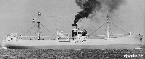
1938, Denmark, as Lotta
Specs:
(280 x 43 ft) 1858 gross tons, 28 crew
Sunk:
Friday March 13, 1942
– torpedoed by U-404 – 27 casualties
Depth:
95 ft.
Chilean ship, the Tolten was torpedoed and sunk by a German submarine early in the war. The U-boat crews called this period of the war “The Happy Time”, since their marauding off the U.S. coastline went almost completely unopposed. The Toltenwas actually the Danish ship Lotta, which was taken over and renamed by the Chilean government after Denmark fell to the Germans. After the war the U-boat captain admitted that in the dark he could not tell what ship he was firing on. The U-404 sank the Lemuel Burrows the next day. After the war the wreck was wire dragged to reduce its menace to shipping.
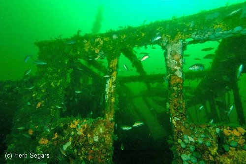
As with many wrecks like this, most of the remaining structure is found at the bow and stern, while in-between is mostly a flattened-out. The broken bow rises at least 20 ft off the bottom, and in the stern area there are several large enclosed spaces that may be entered. The wreck lies roughly east-west and is contiguous, which simplifies navigation.
Much of the wreckage is overgrown with a luxurious layer of hydroids, anemones, and other marine life. Lobstering seems to be better along the south edge, in and around the fallen masts and hull plates, and the Tolten is a regular producer in this regard. Conditions this far offshore are often excellent, although this is usually a chilly dive.

Type:
schooner barge
Depth:
80 ft.
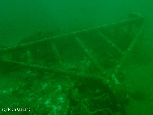
You might first guess that the 120 Wreck is named for its depth, but actually it is named for the 120 degree compass heading taken to get to it from Manasquan Inlet. The real name of this wreck is long lost to time, just another expendable schooner barge from the late 1800’s / early 1900’s.
Today the 120 Wreck consists of a nearly contiguous low wooden debris field, perhaps 200 feet long. A large towing bit near the bow indicates that this was a schooner barge and not a self-propelled sailing ship. At the other end of the site, a lost scallop dredge is wedged into the stern of the wreck.
The ribs and decking form many holes, tunnels, and overhangs, ideal homes for sea life, of which there is a great deal. Large crabs, Sea Bass, Blackfish, and ling can be found, as well as an abundance of lobsters. In fact, this part of the wreck is often referred to as “Heartbreak Alley” – a choice lobster every two feet or so, all out of reach! Smaller pieces of wreckage ( not shown ) lie scattered around the area.


The Sea Girt reef is located atop an underwater ridge known as the “Klondike”. This is an area of clean sandy bottoms, and usually has relatively good visibility. Fish life abounds on all sites in this reef, although lobstering is slim.
There are many more Army tanks than shown here, as well as quite a bit of concrete rubble scattered throughout the reef.
The Sea Girt Reef is one of the oldest artificial reef sites in New Jersey. Reef-building activities at this site date back to 1937. Minimum clearance at mean low water is 50 feet.
To learn more about those artificial reefs that are 3.6 Nautical Miles off Sea Girt (listed below), you can find details about them at https://njscuba.net :
|
|
2025 Copyright: Nick Caruso Enterprises, Inc.
All rights reserved
Website by
Panzigdesigns.com